Drought continues across Texas, U.S.

Image
  • Drought continues across Texas, U.S.
    Drought continues across Texas, U.S.
Body

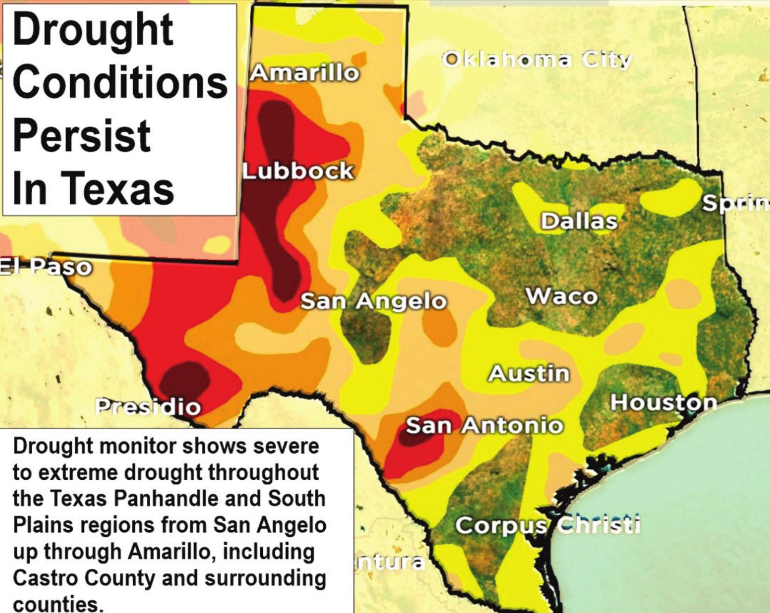
A rapidly expanding drought cycle that took the country from just 8 percent with dry, drought-like conditions in spring 2019 continued to more than 58 percent by fall 2020, according to Bill Kirk, CEO of Weather Trends 360.

This was the most widespread dry-drought coverage across the United States since 2013 after three near-record wet years in a row for the United States overall. The driest conditions were in the western half of the country but extended all the way into the western Corn Belt (Iowa) and up into central Wisconsin.

Currently the latest drought monitor shows expanding drought across much of Texas. Forty-five percent of the state is currently experiencing drought conditions.

Iowa was the driest in eight years following two very wet years in a row. The Northeast was also extremely dry. The wet spots were from Arkansas to Virginia, where rainfall for the year was the highest in more than 35 years due, in part, to remnants from several tropical systems. The West Coast had a wet 2019 but 2020 has been the driest in five years. All the vegetative growth last year was fuel for the wildfires in 2020.

Then an African Sahara dust plume decided to invade the United States with a potent thick cloud that swept the entire Atlantic. It made it all the way to Nebraska by late June. This was the thickest and most widespread event in 17 years but made for some pretty sunsets.

As the dust settled, the Atlantic roared to life with a torrid pace of tropical storms and hurricanes, with 25 systems by late September. This puts the 2020 season in the No. 2 spot for the most active season in 169 years of records; it’s very likely that will break the record of 27 systems set in 2005.

The other twisty critters, tornadoes, were not so bad this year with 1,153 by late September – 5 percent below average, 32 percent less than last year, and 45 percent less than the extreme 2011 season.

But – and Kirk says there is always a but – there were memorable severe weather events, like the August 10 derecho straight-line winds that swept some 700 miles from Nebraska to Indiana. Iowa took the brunt of that straight-line wind event. This was not a small-scale tornado: It carried wind gusts of 110 to 140 mph, the equivalent of a category 3 or 4 hurricane. Upwards of 40 percent of crops in Iowa were severely damaged or destroyed, costing more than $4 billion, the most extreme derecho since 2009.

Then came winter … in summer for the Rocky Mountains and Front Range. Many locations had their earliest measurable snowfall on record with the September 7-9 event.

Most of these extremes can be explained by three climate cycles teaming up for 2020 and 2021: La Niña, the cooling of the equatorial Pacific Ocean, combined with the coldest Pacific decadal oscillation cycle (PDO) in many years but with a still warm Atlantic multidecadal oscillation cycle (AMO). These typically bring drought, very active hurricane seasons, and not-so-extreme winters. Two of three have happened.

Kirk said it remains to be seen if it holds true for a slightly cooler and snowier winter than last year’s hot and not-so-snowy winter; still, it is expected to be warmer than normal for much of the United States with widespread, below-average snowfall.

A FarmCast subscription for forecasts looking out up to 365 days can be found at wt360.com/ag for $399 a year.